
The short answer
Cheesman Canyon is 3.5 miles of Gold Medal South Platte tailwater below Cheesman Dam — catch-and-release, artificial flies and lures only — ending at the Wigwam Club private boundary. You reach it on foot alone: the Gill Trail (#610) off County Road 126, 1.3 miles that rolls rather than drops, 25–35 minutes down and longer back up. The fish are wild browns and rainbows, mostly 14 to 20 inches with a few to 24, holding in water so clear you spot them before the cast. Bring chest waders, 6X–7X fluorocarbon, and small stuff — midges, RS2s, PMDs. It fishes best from 250 to 400 CFS.
At a glance
- Water type
- Hike-in gorge below Cheesman Dam — granite walls, cobble and boulder bottom, and clarity that shows you the bed at eight feet.
- The reach
- Cheesman Reservoir dam downstream to the Wigwam Club private boundary, roughly 3.5 miles. The trail meets the river about halfway along it.
- Regulations
- Catch-and-release, artificial flies and lures only — every trout goes back immediately, at any size, in any season. Possession of bait inside the reach is a violation whether or not it leaves your pack. Gold Medal water. The downstream private boundary is signed.
- Flows that matter
- 250–400 CFS is the productive window. Winter releases run far lower and swing by year: about 55–60 in a dry winter, 110–180 in a wetter one (10-winter median about 120, DWR gauge). Either way it's well under the band, and the river shrinks into its deep slots.
- Live gauge
- CO DWR station PLACHECO. The USGS station on this stretch carries no real-time feed, which is why the chart runs on DWR data.
- Tippet
- Fluorocarbon, 6X as the minimum and 7X as the standard.
Getting there, and what's on the ground
- Drive from Denver
- About an hour and a quarter: US 285 southwest to Pine Junction, roughly 35 miles, then CR 126 south for another 22 through Buffalo Creek. The Gill Trail lot is off 126, just short of Deckers.
- Drive from Colorado Springs
- An hour and a quarter to an hour and a half. Either US 24 west and north on CO-67, or US 24 to Lake George and up Tarryall Road onto the CR 126 network.
- Trailhead parking
- A Forest Service lot, 20 to 25 vehicles. Full by 6:30 or 7:00 on weekend mornings, April to October. Overflow goes onto the CR 126 verge — legal, and it lengthens a walk that was already the longest part of the day. Midweek it is rarely full before nine.
- Day-use fee
- None. The lot is managed by the Forest Service and day use is free.
- Toilets and water
- One vault toilet at the lot. No running water, no other services. Fill up before you turn onto 126 and carry at least 32 ounces for each direction — the walk out is the thirsty half.
- The walk in
- Gill Trail, Forest Service #610. One and three-tenths miles to the water: 25–35 minutes down, 35–50 back with wet gear, on uneven granite the whole way. Trailhead 6,548 feet, river at much the same elevation — so the trail rolls, and there is no long descent to enjoy on the way in.
- Winter traction
- Shaded sections ice over after an overnight freeze. Microspikes from October through March: with traction the way down is manageable, without it genuinely dangerous.
- Road conditions
- CR 126 is paved and kept open all year, and normally driveable in any season in a suitable vehicle. Check after a significant snowfall.
- Nearest fly shop
- Flies & Lies, down in Deckers — the nearest counter to this canyon.
- Nearest lodging
- Bailey, about 30 minutes, or Conifer, about 40. Plan on a commute.
Rows I can't source are left off this table rather than guessed at.
Hatch reports
Latest of 21Latest conditions, flows, and what's hatching on this section.
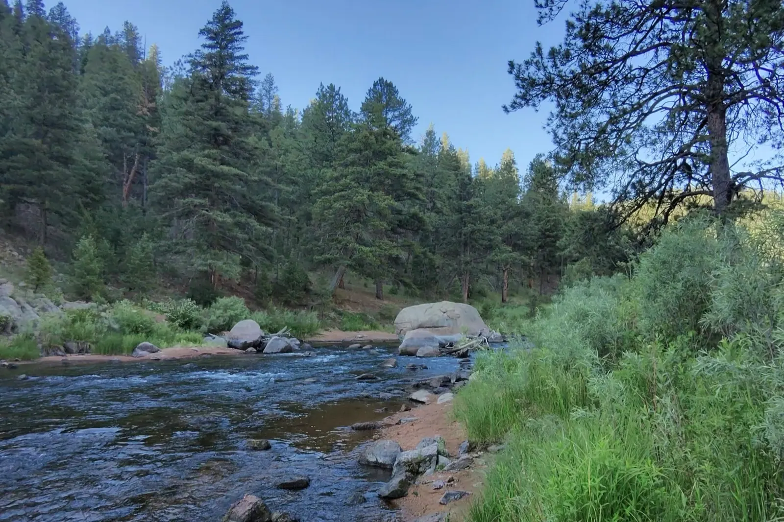
Cheesman is where the South Platte stops being polite. It’s the hardest water I fish, and on its day the best — technical enough that a clean drift feels like something you earned, because you did.
Why the canyon is what it is
Two things made this water: the dam and the regulations.
The dam is upstream, and it releases cold and clear year-round. That gives the canyon a stable temperature regime and a bug population that never really shuts off — midges hatch in January the same as they hatch in July. It also gives the canyon its clarity, which in normal conditions lets you see the riverbed at eight feet. That clarity is the whole character of the place — it’s why you can sight-fish here, and it’s why the fish see you first.
The regulations are the other half. This reach is artificial flies and lures only, and all trout must be returned to the water immediately. No harvest, at any size, in any season. No bait either — and possession of bait inside a catch-and-release reach is a violation whether or not it ever comes out of your pack. The downstream boundary at the Wigwam Club’s private water is signed; don’t fish past it. Decades of those rules, on water this productive, stack up into a population of wild browns and rainbows about as thick and as big as any public tailwater in the state holds.
The trade is that every one of these fish has a history, most of them more than once over. They’ve been shown every pattern in the bins and schooled by a steady parade of good anglers their whole lives. That’s what people mean when they call Cheesman hard, and it has nothing to do with scarcity — there are fish everywhere and you can see most of them. They are simply very difficult to fool.
Regulations get revised annually and the reach boundaries genuinely matter on this river, so treat the above as orientation rather than authority — the signage at the trailhead and the current CPW brochure are what settle it.
The hike in, and what it costs you
The Gill Trail is Forest Service #610, off County Road 126. It runs 1.3 miles one way down to the water and the footing is uneven granite the whole way. It rolls rather than drops. The trailhead sits at 6,548 feet and the river only a hair below it, so the effort is a run of short climbs in both directions rather than one long descent to coast down. Don’t be thrown if you’ve seen #610 listed as a five-mile trail — that figure is the whole thing, continuing on past the river toward Cheesman Reservoir at the top. Getting to fishable water is the shorter number. Twenty-five to thirty-five minutes going down. Thirty-five to fifty coming back up with wet gear and tired legs — and that second number is the one people underestimate.
There is a second approach, the Wigwam Trail, which comes at the canyon from below. Either way it’s foot access. There is no road to this water.
The hike is the filter. It’s why the canyon holds its fish and why a weekday morning down there can be genuinely quiet while the roadside water downstream is stacked. It’s also a cost you pay at the end of the day rather than the beginning, so plan around the walk out. Pack once, pack light, and hike in trail shoes with your wading boots carried — felt on dry granite is worse than useless.
October through March, carry microspikes. Ice forms on the shaded sections after an overnight freeze and the descent goes from manageable to genuinely dangerous without traction. This is not a place to improvise.
What the water actually looks like
Once you’re down, you have 3.5 miles of river running at the base of steep granite walls over a cobble and boulder bottom. The trail drops you roughly halfway along it, so you can work upstream toward the dam or downstream toward the private boundary.
Three kinds of water, and they fish like three different rivers.
Pocket water. Boulder-broken, fast, with holding lies tucked behind and beside rock. The broken surface is what covers you — it’s the one place in the canyon where a fish can’t study your leader for two full seconds before deciding. It’s also the one place you can fish heavy and close. The slot behind a rock might be three feet long, which means the flies have to be at depth the instant they land or the drift is over before it starts: a short tight-line pass with the rod held high and a weighted point fly beats an indicator rig that spends the whole pocket sinking.
Deep slots. Where the granite drops straight into the river, you get chest-deep channels of slow, heavy water. These hold the canyon’s biggest fish, and they hold them all year, but especially in the cold months. They’re also where the wading gets serious. Fish them slow and genuinely deep — a pair of nymphs suspended beneath a small indicator, weighted enough to reach the bottom of water that’s over your head, is the surest way to move a fish in here once the water turns cold. The takes are soft and the drift has to be long enough to matter, so resist the urge to recast every eight feet.
The flats. Slow, wide, glassy, and shallow enough to see everything. This is where the canyon’s reputation was earned, and the reason is not mysterious. On a flat the surface isn’t broken enough to disguise anything, the current is slow enough that a fish can hold beside your fly and inspect it for as long as it likes, and your leader lands inside its window rather than outside it. Time and visibility, both working against you. What you do about it is subtract: longer leader, finer tippet, fewer casts, and a stalk into position rather than a wade into it. Every instinct carried over from pocket water — more weight, get closer, throw again — empties a flat. It’s also where the best dry-fly fishing in the canyon happens, which is what the discipline buys you.
Depth ranges from ankle-deep riffle to over your chest. Full chest waders, not hip boots, and not a summer wet-wade. Several stretches have no practical crossing at all — scout your exit before you commit to the far bank, because the walk back around can be long.
Reading it
The canyon rewards fishing methodically far more than it rewards covering ground. The most common mistake in here — and one I made for a long time myself — is wading to the middle and casting to the far bank, which drags line over every close fish before you’ve had a chance at them. Work the near water first. Always.
What you’re actually reading is granite. The canyon is cut through Pikes Peak granite, so the rock is irregular and the hydraulics don’t obey the diagram in the book — you cannot assume a boulder produces the textbook cushion. Two separate lies come off every big rock, and they are not the same lie. Behind it sits a soft hydraulic pocket where a fish can rest and ambush. In front of it sits a deflection seam, where the current splits around the rock and funnels drifting food into a narrow band. Fish use both, and which one they’re in depends on whether anything is coming off: with a hatch on, they slide forward onto the front seam, because that’s where the food concentrates. I’ve worked an empty back pocket for twenty minutes and then moved three feet upstream to find fish stacked on the seam in front of the same rock. Check the front before you decide a boulder is empty.
The other read that pays here is the drop-pool lip. Where a fast riffle tips into a slower pool, fish sit just past the lip in the first four to six feet, where the speed falls off — the riffle brings oxygen and drifting nymphs, the pool provides soft water to hold in. In the canyon those transitions are often only two or three feet wide, so you’re presenting into a small target and the angle matters more than the distance: come at it from upstream, keep your shadow off it, and get the fly down fast enough that it’s fishing by the time it reaches the lip rather than still sinking past it. I’ve broken the same lies down across Deckers and the Dream Stream too, which is a useful comparison — the principle is identical and the scale is completely different.
Position beats pattern here by a wide margin. Get into casting range without putting your shadow or your wake on the lane, then get one clean drag-free drift before the fish knows anything is happening. The first drift through a lane is worth more than the next ten. Once a fish in clear water has seen the leader, you are usually just confirming that it saw the leader.
Slow feet, long leaders, shadows off the water. That doesn’t change much between March and November.
Seeing them before they see you
The clarity here is a tool as much as it’s a hazard, and most people never pick it up. Fish the canyon as a hunt: find one, then plan the cast around it.
A holding trout in clear water almost never looks like a trout. It reads as a soft dark smudge that doesn’t quite match the bottom; as a hard-edged shadow on the gravel, which is often easier to see than the fish throwing it; as a quick wink of a flank when it turns to take something; or as a blink of white when a mouth opens on a nymph. You’re hunting the clue, not the animal. And anything that moves sideways against the current is a fish — nothing else in the river does that.
Two things decide whether you see any of it. Polarized lenses, which block the horizontal glare coming off the surface and let you look into the water instead of off the top of it — copper or amber lifts a tan fish off tan gravel better than grey, and the buying side is written up separately. And the sun at your back, which costs nothing and matters about as much as the glasses do. In a river running between two walls, the light is frequently the whole reason to fish one bank rather than the other.
Then watch the fish before you do anything to it. A couple of minutes tells you which way it’s facing, how often it’s eating, and whether it’s working up near the surface or rooting along the bottom — which is your depth answer, and a far better one than guessing. Approach low and slow, from downstream and off to the side. Don’t false-cast over it: false-cast out to the bank and deliver on the last stroke. Line shadow and a leader landing hard spook more spotted fish in here than the fly ever does.
Two beats worth knowing
The trail drops you at the river roughly halfway along the canyon, and there are two pieces of water either side of that point I’d send anyone to first.
The run below the Gill Trail junction. The most walked-to water in the canyon and, density being what it is, still the one that produces best. A long tailout with a well-defined seam down the far bank, and when a hatch is on the fish line up along it. The trap is built into the geometry: the far seam is the obvious target, and the wade out to reach it drags your line over every fish between you and it. Fish the near half thoroughly first and only then reposition. And because this is the most-covered water in the canyon, go finer than you think you need to — these are the fish with the longest memory of other people’s tippet.
The deep slow water upstream of the junction. Keep walking past the obvious water and the crowd thins fast — that walk is precisely why fewer people are standing in it. Slow, deep, and home to the biggest fish in here, which come up for the spring dry-fly hatch as readily as they hold underneath it. It’s a demanding approach with limited casting room, so plan the cast before you plan the wade: work out where you can physically stand and what you can deliver from there, because there is often no second position to move to if the first one doesn’t work. Slow deep water means the flats rules above apply in full.
If neither of those sounds like a first day, try the broad flat down toward the private boundary, just inside the canyon mouth: easier gradient, wider channel, and evening caddis that pull fish into the slow water. Gentler ground than the upper canyon. The fish are not gentler.
Flows, and what the numbers mean
The gauge for this water is the CO DWR station, abbreviation PLACHECO — it’s the live chart at the top of this page. The USGS station on this stretch has no real-time feed, which is why this page runs on DWR data.
250–400 CFS is the productive window, and it’s a fairly wide one. Inside it the canyon fishes as designed: the slots hold, the pocket water is workable, and the flats are clear enough to sight-fish. One honest caveat for anyone reading after a dry year: that band is a normal-year reference. Through the 2026 drought summer the canyon mostly ran below it — this site’s own weekly reports had it between roughly 190 and 300 CFS, under the 250 floor more often than not. A reading in the low 200s here is not a warning sign; it is what a drought year looks like, and the fish concentrate into the deeper water accordingly.
Toward the bottom of that band, everything gets harder in the way lower, clearer water always does. Fish back into the deepest lies, and at that range every fish gets a long, unhurried look at what you are offering it. 7X and small flies, and no hurry about any of it.
Toward the top of it, the pocket water becomes the better bet and the flats get harder to read. More current means more forgiveness, but it also means the wading tightens up. Even in the moderate part of the range — 300–350 CFS — the main channel runs fast and the rock is slick, so a bigger number is not an invitation to be casual about crossings.
The concrete thing the number changes is where the fish are sitting, more than what they’ll eat. Down at the low end the pocket lies concentrate: fish stack tight behind individual boulders, and the rock-by-rock game is the fishery. Push above roughly 400 and those pockets wash out — the fish move onto bank structure and the softer edges along the walls, and working boulder to boulder stops paying. Read the number as a question about position before you read it as a question about pattern.
I’m not going to hand you a band-by-band chart of numbers for Cheesman the way I would for Deckers. Releases from Cheesman Reservoir are a management decision rather than a weather event, and the canyon’s character changes with the release more than with the season. Watch the chart, and watch which direction it has been moving for the past week. What the number has been doing matters as much as what it is: a canyon still adjusting to a change in release does not fish like one that has settled into it.
Hatches through the year
Winter (December–February). Be honest with yourself about this one. The canyon is open, the fish are there, and the midges never stop — but December and January are the hardest fishing of the year here, not a quieter version of the good months. Midges, and effectively only midges, sizes 20–26. Winter releases run lower than the rest of the year, often 50–75 CFS, which is under the productive band above: the river shrinks into its deep slots and the fish go with it. Water in the upper 30s. Gin-clear. The walls keep the river in shadow until nine or ten and the feeding window is roughly 11 to 2, so this is the one season that genuinely rewards sleeping in. Fish the deep slots and the pools beneath the walls, expect fish to sip rather than move, and expect to earn every one of them on 6X or 7X with a drift you’d be happy to show someone. The reward for all of that is a canyon with nobody in it and the chance at the largest fish in it. If you want a day where the river meets you halfway, come back in October. If you want the canyon to yourself and you’re willing to fish perfectly for four hours to get three takes, this is the season.
And treat the Gill Trail as part of the decision, not a formality. It ices, the canyon gets little sun to clear it, and ice shelves build along the shadowed walls at the water’s edge. Traction devices, not optimism. The winter South Platte guide has the full cold-weather rig and the layering that keeps you out there through the window.
Spring (March–April). BWOs begin on overcast days, and they bring the year’s first dependable dry-fly fishing with them. Water is still cold; the midge rig still earns its keep underneath.
Late April into June. The PMD window runs late April through May, and it’s the event everyone here waits for — the finest dry-fly fishing the canyon gives up all year. PMDs taper through June as the caddis start. May also draws the heaviest crowds of the season, and the lot fills early on weekends.
Summer (July–August). Midday goes quiet in the heat, and the honest answer is to make it a morning trip rather than to grind through the middle of the day. A cold-water release buys you time and distance, not immunity — it keeps warming the further it travels from the dam, so check the temperature where you’re actually standing rather than assuming the tailwater covers you. When to stop fishing is a decision, not a detail. Fish early, and take the evening caddis in the lower canyon where the gradient eases.
Autumn (September–October). Late September into October is BWO season and, to my mind, the best six weeks the canyon offers. The walls throw shade and shelter that concentrate emergence even when the ground above is in partial sun, which is why fall BWOs fish better here than anywhere else on the system. Go to #22 dries on a 12-foot 5X leader tipped with 24 inches of 7X. The run below the Gill Trail junction and the deep slot well upstream of the junction are the two most consistent fall beats — how to fish each of them is above. The fall BWO guide covers the patterns and the rise-reading in detail.
November. Midges return and the crowds go away entirely.
Crowds, and how to fish around them
The hike filters out a lot of people. It does not filter out May.
Weekend mornings from April through October, the trailhead lot fills early and latecomers park along the road, which adds to a walk that was already the longest part of the day. Midweek is a different river — Tuesday through Thursday it is rarely full before nine. If your schedule bends at all, this is the water to bend it for. The access guide has the parking specifics, and there is no water at the trailhead, so fill up before you turn onto 126 and carry enough for both directions. The walk out is the thirsty half.
The in-canyon workaround is the usual one with more consequence attached: walk. The trail junction concentrates people, and pressure drops off in both directions from it. The upstream section toward the dam is generally the quieter half, for the straightforward reason that it costs more to reach.
The box
Nothing here is exotic. What matters is size and how fine you’re willing to fish it.
- Zebra Midge, #22 and #24 — year-round, and the whole of winter.
- RS2, #20 to #24 — the emerger, and the most useful single fly in the canyon. Gray or olive, dropped below a dry early in a hatch or fished on its own when the rises are film sips rather than clean takes. There’s a full RS2 write-up if you want the tying and fishing detail.
- Sparkle Dun PMD, #18 and #20 — May and June.
- Parachute BWO, #20 and #22 — spring and fall, and the one you reach for when you need to actually see your fly.
- Griffith’s Gnat, #20 and #22 — calm afternoons with midges clustering.
- Elk Hair Caddis, #16 — evenings, lower canyon.
- Woolly Bugger, #8 and #10 — early and late season.
If the pocket water is what you’re after, a tight-line rig is the better tool than an indicator, and the euro nymphing setup for the South Platte is the leader I use for it. In the canyon’s low-gradient water it finds takes you would never see move an indicator.
Tackle and tippet
Fluorocarbon, 6X minimum, 7X standard. On this water that is the difference between a take and a refusal, over and over. When the canyon beats someone, the cause is usually diameter and weight rather than pattern.
The other half of fishing 7X is what you do when it works, and it’s where most of the canyon’s heartbreak lives. A hard trout-set snaps thin tippet at the knot before the hook has properly bitten. The move is a firm, smooth lift — set the wrist, not the shoulder, and let the rod’s flex and the line’s stretch do the cushioning. Then play the fish off the reel and give it more room than feels comfortable, because a big fish on tippet that fine is a negotiation rather than a fight. Check your knots before you go down to 7X, not after. A break-off leaves a fish swimming around with your fly in it, which on catch-and-release water is a real cost and not a punchline.
A 9-foot 5-weight is the rod. It handles the long leaders the flats demand and still turns over a weighted two-fly rig in the pocket water, which is the whole range of what this canyon asks. Leaders: 9-foot 5X as a floor, 12-foot for flat-water dry-fly work. Full chest waders. A wading staff, every trip and every season — mine doesn’t come off the sling. The granite is uneven under water you can see through perfectly, which is its own trap, and the descent gives you a use for it before you’ve even reached the river. A vest, sling, or chest pack rather than a backpack — lower profile in the current and one less thing catching wind.
And a headlamp, every trip, regardless of when you plan to leave. Understand what you are signing up for on the way out: this is a hard hike, not a stroll back to the truck. Trailhead and river sit within a few feet of each other at around 6,548, so this is not the 600-foot climb-out you may have read about somewhere — but the trail rolls, and you go up as much as you come down, both directions. Uneven granite, at the end of a day standing in cold water, carrying wet gear. The way in flatters you because the hard parts are short. Turn around with enough left in your legs to do it properly, and set that turnaround by the clock rather than by how the fishing is going — the fishing is always going well at the moment you should be leaving.
Where the canyon fits
Downstream of the Wigwam Club’s private water, the rules change entirely: Deckers is two fish at a 16-inch minimum, roadside, readable, and a far better place to learn a river. Cheesman is the harder version of the same water, and the private reach sitting between them means you can cross a regulation change in a day without anyone telling you.
Come here expecting to work. A good day in the canyon runs to a handful of fish, and a slow one is common and tells you very little about how well you fished. What it will teach you — about tippet, and about the difference between a drift that looks fine and a drift that is actually right — carries to every other river you fish. If it’s your first trip, read the complete access guide before you drive up; it covers the parking, the road, the beats, and what to leave in the car.
The canyon is worth the walk.
Common questions
6 answered- Can you drive to Cheesman Canyon?
- No. There is no road to this water. Access is on foot, either down the Gill Trail from County Road 126 or up the Wigwam Trail from below.
- How long is the hike into Cheesman Canyon?
- One and three-tenths miles from the lot to fishable water: 25 to 35 minutes going down, 35 to 50 coming back with gear. It rolls rather than drops — trailhead and river sit at much the same elevation, 6,548 feet by the Forest Service's reckoning, so what tires you is a run of short climbs in both directions rather than one big haul. And if you have seen #610 given as five miles, that is the whole trail, running on upstream to the reservoir. Not your walk.
- Is there a fee or a toilet at the trailhead?
- No fee: the lot is Forest Service ground and day use costs nothing. One vault toilet, no running water, nothing else. Fill your bottles before you turn onto 126.
- How early do I have to get there?
- Twenty to twenty-five vehicles fit, and on an April-to-October weekend they are all there by 6:30 or 7:00. Midweek is a different river: Tuesday to Thursday the lot is rarely full before nine. If your schedule bends at all, this is the water to bend it for.
- What are the rules in the canyon?
- Catch-and-release, artificial flies and lures only. Every trout goes back immediately, whatever its size and whatever the season, and simply carrying bait into the reach is a violation of its own. The private boundary downstream is signed — that sign is the end of the public water. Regulations get revised annually; the trailhead signage and the current CPW brochure are the authority.
- Do I need traction for the trail in winter?
- From October through March, yes. Ice builds on the shaded sections after an overnight freeze and the canyon gets little sun to clear it. Microspikes, not optimism — this is not a place to improvise.